Documenting War Crimes in Sudan Begins Now – Foreign Policy
As a war correspondent in the 1990s, I witnessed the world’s failure to prevent two genocides, and the struggle to hold the perpetrators accountable afterward.
In Bosnia in 1995, more than 8,000 Muslim men and boys were massacred in Srebrenica, a city declared a safe haven by the United Nations. In Rwanda in 1994, an estimated 800,000 people were killed over the course of 100 days. Both atrocities occurred under the watchful eye of the international community and revealed how ill-equipped it is to collect and preserve evidence of crimes against humanity.
At the time, investigations relied on survivor testimonies, journalists’ observations, and the slow and harrowing work of exhuming bodies from mass graves. When the International Criminal Tribunal for the former Yugoslavia began its investigation into the Srebrenica incident in 1996, Serb forces had already exhumed and reburied the bodies to hide the evidence. But something new has emerged from Bosnia: satellite images.
US intelligence used satellites and geospatial intelligence to detect disturbed soil around villages near Srebrenica, such as Bjelica and Nova Kasaba, which are potential mass grave sites. The images were crude and often secret, but they marked the beginning of a technological revolution in accountability, generating international pressure, as well as helping to guide on-the-ground research. The photos were used as evidence in war crimes investigations, shared with the United Nations and the International Criminal Tribunal for the Former Yugoslavia, and later displayed publicly.
By contrast, in Rwanda, there were no satellites, no drones, and access to forensic medicine was limited. Much of this is due to the speed with which the genocide unfolded and the lack of international monitoring on the ground. The UN had a limited mandate in Rwanda, and initially, there were few international correspondents there. More importantly, satellite images were expensive at the time, and identifying graves in Rwanda from above was particularly difficult due to the country’s dense forests and remote rural areas.
Instead, investigators – UN human rights experts, journalists, and later a UN panel of experts – relied almost entirely on human testimony. The result was a slow and painful process. The thousands of testimonies collected were indispensable to telling the truth and to the gacaca courts, a transitional justice system. The UN international tribunal for Rwanda opened in 1994 and closed in 2015, bringing charges against 93 people during that period – but it was neither quick nor comprehensive justice.
More than 30 years later, war crimes investigation tools have been transformed beyond recognition due to radical changes in technology. What once relied on a handful of investigators now relies on terabytes of data, photographs and radio intercepts. Open source intelligence, or OSINT, has redefined how atrocities are tracked, verified, and prosecuted.
The ICC began systematically using satellite imagery in its investigations in Darfur, Sudan, in the mid-2000s. During the civil war in Syria, the American Association for the Advancement of Science published open analyzes of destroyed villages and mass graves. In Syria, NGOs have also used commercial satellite imagery to identify bombed hospitals, massacres, and detention sites. Citizen journalists in cities like Aleppo picked up evidence of barrel bombs and double bombings — two strikes carried out in quick succession, so the second strike hit first responders who helped victims of the first — by Russian aircraft.
A new generation of digital sleuths soon followed. Bellingcat, an investigative journalism group, used open source tools first to identify the perpetrators of attacks in Syria, and then to identify Russian forces in Ukraine. Forensic Architecture, founded by a British-Israeli architect in London, has reconstructed bombings using architectural modeling and geolocation data in cases such as the airstrike on a theater in Mariupol, Ukraine, in March 2022.
Many major newspapers, incl New York Timeslaunched its own investigation teams relying on OSINT specialists. The FBI has blurred the line between journalism and criminal investigation, and made impunity more difficult. Investigations now create public records of crimes that cannot be erased or denied. Everyone has a phone, and phones have cameras; Organizations like Eyewitness now work with citizens in war zones to capture images and document atrocities in real time, imposing moral and political consequences.
When I started reporting on the wars in the late 1980s in Gaza and the West Bank, my tools were a notebook, then a coffee-table-sized satellite phone. There was no internet, no social media, and no instant photos. Today, my organization – the Numeracy Project – works differently. We combine OSINT, satellite analysis, and digital verification with traditional witness interviews and human intelligence. We train journalists and lawyers to work together so that evidence collected in the field is admissible in court. We work directly with prosecutors, helping them build their cases.
The Computation Project held a symposium at Yale University in early November titled “How to Catch a 21st Century War Criminal.” Our focus was on three current conflicts – the war between Israel and Hamas in Gaza, the war between Russia and Ukraine, and the civil war in Sudan – and how technology has transformed the pursuit of justice. We’ve brought together lawyers, analysts, data scientists and journalists to see how we can fight crime and catch the perpetrators sooner.
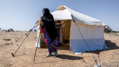
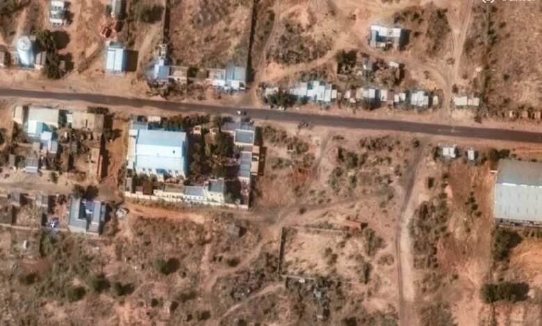
In Sudan, where more than 150,000 people are estimated to have died in fighting between the Sudanese Armed Forces and the paramilitary Rapid Support Forces since April 2023, the evidence is literally visible from space. In October, the city of El Fasher fell to the Rapid Support Forces after a harsh 18-month siege, with gaps in food, electricity and water supplies reaching critical levels. Following the takeover, there were reports of mass executions, rape, deliberate obstruction of aid, as well as mass graves.
The fall of El Fasher represents a decisive moment. It is tragically too late to prevent what the US State Department has already called genocide – despite the desperate efforts of committed UN officials like Tom Fletcher of the Office for the Coordination of Humanitarian Affairs, who visited Sudan last week. (Fletcher described El Fasher as a “crime scene.”) But now is the time to move on to documentation and possible prosecution. Stopping the ongoing violence is urgent, but so is gathering evidence.
“From the skies of El Fasher, satellites pick up the patches of communities that have been deliberately erased,” said Kuskondi Abdel Shafi, a Sudanese consultant at Freedom House, speaking at the Yale conference. “Yet the world remains deaf to the cries that rise louder than the sound of cannons. The groans of raped children and women echo through the rubble, demanding not sympathy, but justice.”
The Yale Human Research Laboratory released satellite images showing “disturbances consistent with mass graves” outside El Fasher. The photographs appear to show the systematic disposal of bodies, in other words, a clean-up process after the massacres. Such images could help change the international community’s view of Sudan as an internal political conflict. The Yale lab’s research not only showed evidence that could indicate genocidal intent, but also patterns of intentional targeting of civilians. For policymakers, such reports can turn claims into facts.
Jehan Henry, a veteran Sudanese analyst who leads the Reckoning Project’s work in Darfur, described the deluge of evidence coming out of the region via smartphones and social media.
She added: “We have seen RSF fighters filming themselves killing civilians and bragging about it. Human rights groups have verified and compared those images, matched them with satellite data, and even identified individual commanders.” “There is no longer any doubt about the violations.”
This convergence of evidence – witness accounts, geolocation, metadata, and satellite imagery – makes it more difficult than ever for perpetrators to deny crimes. It also makes it easier for those on the ground to act quickly: in some cases, analysts can detect atrocities as they happen, allowing humanitarian organizations to warn civilians before an attack occurs or preserve evidence before it disappears.
But technology is not justice. Satellites can detect atrocities, but they cannot prosecute their perpetrators. OSINT can verify evidence, but it cannot enforce international law. The gap between evidence and accountability remains wide – not because we lack the tools, but because we lack the political will to act on what we have at hand and prosecute the perpetrators of atrocities.
The challenge now is to integrate digital evidence into formal justice mechanisms. Courts must adapt to new forms of verification and work more seamlessly with civil society. States must be prepared to act on the information they already have by committing to arrest perpetrators. Citizens must demand that important data does not remain just pixels on a screen.
As Sudanese lawyer Mutasim Ali told me, “Open source intelligence and satellite images not only serve as evidence – they can save lives when the world fails to act” – and went on to say that we must inform people about these incidents to try to stop the atrocities now. and To prevent those in the future. And he’s right: technology has become the witness that cannot be silenced, and the question is whether the rest of the world will choose to listen.
Don’t miss more hot News like this! Click here to discover the latest in Politics news!
2025-11-21 16:00:00